Channel Islands of California
The Channel Islands of California  are eight mountainous islands off the coast of the Los Angeles area in California, United States (see map). Four of the islands have airports:
- Santa Catalina Island
- Catalina, Avalon (KAVX) aka. "Airport in the Sky"
 . 3000' asphalt runway with VOR and GPS approach.
 - Pebbly Beach, Avalon Bay (L11). Water runway.
- Catalina, Avalon (KAVX) aka. "Airport in the Sky"
- San Clemente Island (US navy)
- San Clemente Island Naval Auxiliary Landing Field (KNUC). 9300' conrete runway with NDB approach.
- San Nicolas Island (US navy)
- San Nicolas Island Navy Outlying Field (KNSI). 10000' asphalt runway with ILS approach.
- Santa Cruz Island
- Santa Cruz Island (SZN). Dirt airstrip.
- Christy Airstrip (CA97). Grass airstrip.
Taxi flight LAX - Catalina
It's afternoon and a passenger has just arrived at Los Angeles International Airport (KLAX), waiting for a taxi flight home to Avalon, Santa Catalina Island, via Catalina Airport (KAVX).
Setup: Select the Beechcraft Baron 58, set location to KLAX, and time to dusk.
VFR: After takeoff turn heading 167° and proceed direct to the island (VOR 111.4 inbound).
IFR: File a direct flight plan KLAX-KAVX. Right after takeoff you may choose one of the approaches VOR/DME or GPS-B or VOR or GPS-A.
KAVX has a 3000' long runway at 1600' elevation.
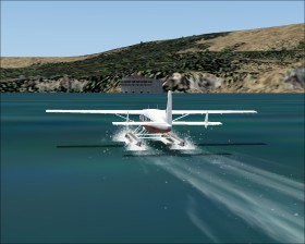
Scheduled floatplane flight Long Beach - Avalon Bay
It's a early sunny morning and a small group of tourists are waiting at the Long Beach harbor for the scheduled floatplane flight to Avalon Bay, Santa Catalina Island.
Setup: Select the Cessna C208 Caravan Amphibian, set location to Long Beach (KLGB), weather theme to Clear skies, and season/time to Summer Dawn.
Takeoff from KLGB and turn southwest. Locate the white dome and the Queen Mary ship in the harbor and land next to the ship. Now takeoff and head south for the Avalor Bay (L11) . Land next to the Avalon Casino (the round building).
Helicopter flights
Make one of the helicopter flights operated by Island Express. See their website for additional informations.
Scenery add-ons
Area NA38 from Global Terrain Mesh adds 70m mesh for the entire Los Angeles area including the Channel Islands.
MegaScenery Southern California by PC Aviator.