New York City
New York City, United States, is famous for its many skyscrapers on Manhattan island  . The city is also interesting to fly because it is surrounded by busy airports with a busy airspace.
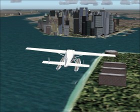
Choose a seaplane (e.g. the Cessna Caravan Amphibian) for this tour. Takeoff from the famous John F. Kennedy (KJFK) and fly south to the coast. Follow the coast to the west until reaching the Verrazano Narrows Bridge. Before you reach the bridge, you will see an animated amusement park at Coney Island (N40*34.44 W73*59.17), a peninsula on the southernmost Brooklyn. From the bridge fly noth and head to the Statue of Liberty and the Manhattan skyline. Fly around Manhattan and land on the water just besides the tall skyscrapers.
Read this page on how to see Manhattan at ground level.
Airport approaches
Because of the detalied and partly photorealistic scenery of New York City there is some published approaches at the local airports that are interesting.
John F. Kennedy (KJFK)
The Canarsie approach to runway 13L/R has a late 93° right turn. In fact this is the only instrument approach for runway 13R. It can be flown as the Parkway Visual and VOR or GPS approach. In real-world pilots have visual guidance from lead-in light clusters as seen on the charts.
The Belmont Visual Runway 22L approach is more difficult because the Expressway is difficult to locate.
La Guardia (KLGA)
The Expressway Visual Runway 31 approach requires a final 129° left turn and gives a good view of Manhattan while approaching. Also here the Expressway is difficult to locate but the Flushing Meadow Park and Shea Stadium are clearly visible.
The River Visual Runway 13 approach is easy and you get a first class view of Manhattan.
My favorite is: Set time to New Year and approach La Guardia via River Visual with the view of the Statue of Liberty, the Manhattan skyline, and the New Year fireworks.
Scenery add-ons
- KLGA New York La Guardia Airport by imagine simulation for FS2004
- KEWR Newark Liberty International Airport by imagine simulation for FS2004
- Scenery Manhattan by Aerosoft for FS2004