Oil platform
There is plenty of oil platforms placed at real-life locations in the scenery of Flight Simulator. The platforms have helipads so you can land on them in a helicopter, or you can just land beside them in a seaplane. Many platforms are equipped with navaids like NDB or DME which make them obvious for instrument flights.
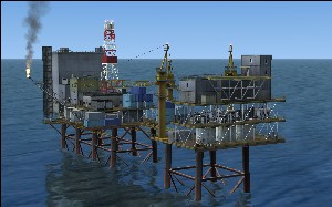
There is two types of oil platforms. A single high-detailed animated oil rig is located in the North Sea at position N52į 12.02' E3į 29.21'.
The other type, less detailed, is found at the following locations.
Canada
| Latitude | Longitude |
|---|
| N69į 33.29' | W138į 58.90' |
Gulf of Guinea
| Latitude | Longitude |
|---|
| N5į 23.24' | E4į 54.21' |
| N2į 23.82' | W12į 29.89' |
Gulf of Mexico (Mexico)
| Latitude | Longitude |
|---|
| N21į 43.16' | W89į 17.50' |
Gulf of Papua
| Latitude | Longitude |
|---|
| S8į 3.86' | E144į 33.63' |
North Sea and Norwegian Sea
| Latitude | Longitude |
|---|
| N55į 28.14' | E5į 7.99' |
| N56į 38.48' | E3į 19.53' |
| N57į 6.63' | E2į 50.68' |
| N58į 22.00' | E1į 54.41' |
| N60į 29.47' | E2į 49.50' |
| N61į 12.39' | E1į 49.76' |
| N61į 12.86' | E2į 16.33' |
| N61į 26.96' | E2į 8.49' |
| N64į 16.25' | E7į 11.98' |
| N65į 19.53' | E7į 18.94' |
Persian Gulf
| Latitude | Longitude |
|---|
| N24į 30.50' | E53į 42.13' |
| N24į 50.00' | E53į 35.99' |
| N24į 53.75' | E53į 42.74' |
USA
| Latitude | Longitude | State |
|---|
| N27į 43.68' | W97į 14.95' | Texas |
| N28į 29.51' | W95į 55.15' |
| N29į 18.52' | W94į 48.41' |
| N28į 5.83' | W90į 47.66' | Louisiana |
| N28į 39.97' | W89į 58.16' |
| N28į 40.45' | W90į 9.46' |
| N28į 41.93' | W91į 13.91' |
| N28į 45.76' | W91į 24.25' |
| N28į 51.66' | W91į 52.76' |
| N29į 5.60' | W89į 45.50' |
| N29į 22.31' | W91į 23.10' |
| N29į 22.90' | W92į 59.20' |
| N29į 26.03' | W93į 27.37' |
| N29į 31.12' | W93į 17.00' |
| N30į 11.33' | W87į 57.15' | Alabama |
| N31į 56.92' | W80į 40.98' | Georgia/
South Carolina |
| N33į 30.74' | W77į 36.50' | North Carolina |
| N36į 19.15' | W93į 55.27' | Arkansas |
| N36į 54.31' | W75į 42.78' | Virginia |