Osaka Bay
This tour takes you to the Osaka Bay  in Japan.
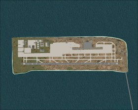
Start in Kansai Intl (RJBB)  . This airport from 1994 is build on an artificial island connected to the mainland with a bridge. You will only see a single runway, however, a second runway is under construction, and a third runway is planned.
After takeoff follow the bridge to the mainland and follow the coast north and later west until you reach a bridge that connects the mainland to the Awaji Island. The Akashi-Kaikyo Bridge is the world's longest bridge. Follow the eastern coast of the island in south direction and return to RJBB.
Kansai approach
The ILS runway 24 approach to Kansai is a bit spetacular. In order to avoid overflying the city, the approach curves in the bay. The localizer is intercepted "only" 5.6 nm from the runway threshold and the glide slope is intercepted at only 1200 ft.