Paris
Paris  is the capital of France and the default scenery contains many of the famous buildings of the city.
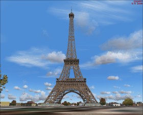
This tour takes you to a famous path in the city. Takeoff from Orly (LFPO). Fly east to the Seine river. Follow the river in north direction for about 9 nm until you reach the island with Notre Dame (church with a black spire). Just where the island ends locate the yellow Tuileries Palace to the right of the river. Follow the road that runs from the palace at about heading 300. This is the Axe historique where you will see a lot of famous buildings and monuments, e.g. the Arc de Triomphe. On the path you will see the Eiffel Tower to the left. Later after crossing the river but still following the road you may fly through the Grande Arche. And by the way - you can't fly under the Eiffel Tower or the Arc de Triomphe unless you have disabled crash detection.
The Palace of Versailles is located south west of the city centre or 2 nm at heading 105 from LFPZ.
Paris has the Charles de Gaulle International Airport (LFPG) which is a major airport with high-detailed scenery. Make a short passenger flight between Chales de Gaulle and Heathrow, London (EGLL), the two greatest airports in Europe with respect to passenger traffic.
Tip: If you set the date to July 14, the French national day, and time to 22.00, you will see fireworks close to the Eiffel Tower.