Paro
Bhutan is a mountainous kingdom in the eastern Himalayas between China and India. The country is worth to pay a visit because of the challenging airport in the Paro valley.
Paro airport
Paro Airport (VQPR) 
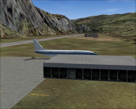
 is the only airport in Bhutan. It is located in a 7300 ft elevated valley and surrounded by 16000 ft peaks. The single runway is 6500 ft. Even though the airport is isolated and complex to fly it is flown by medium size jets.
The terrain makes instrument approaches with small minimums impossible. In the 1996 Jeppesen charts there is only a single instrument approach, a VOR/DME approach with a Minimum Descent Altitude of more than 5000 ft above airport elevation!
See a report on some test flights at Paro with a Boeing 737-700.
Scenery
The elevation of the FS2004 standard mesh surrounding Paro is too high. This means that the airport is located in a hole and more difficult to approach than in the real world. The Himalayan Peaks LOD10 Mesh, Volume 1 - Mt. Everest and Kula Kangri by Holger Sandmann and Jonathan de Ferranti (for FS2004) updates the mesh surrounding Paro.
Paro airport scenery by David Cuvillier (for FS2004) greatly improves the airport scenery, in particular with the local characteristic buildings.
Flights
The airport is only served by the national airline, Druk Air, which has several international destinations. I recommend that you make the 220 nm long scheduled flight from the Nepalese capital, Kathmandu, to Paro (VNKT-VQPR). You will be flying parallel to the Himalayas and close to Mount Everest. The mesh add-on mentioned above covers the entire flight area. The current Druk Air fleet is two Airbus A319-100. Alternatively use the build-in Boeing 737.