Home

Tours

Misc

Search

Forum

Links

About

Peru rivers

Peru rivers, FSX FS2004

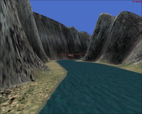
Even though one might doubt that the scenery on this tour is like in the real world, the tour on the Peru rivers is very beautiful.

Takeoff from Col Alfredo Mendivil Duarte (SPHO). Use the map or GPS navigator in terrain mode to locate a low elevation path to the river that starts 48 nm at heading 335 from the airport (the river runs in a half-circle and later joins another river). When reaching the river descent to some few feet above the water and follow it. When the river is separated follow it to the south and land at San Francisco (SPTE) on the left side of the river.

Comments:

Wow! Sounds very interesting, and Fun.
excellente mi amigo
This is a bug, because:
1. Rivers are too wide in this area
2. River location is sometimes very bad (>10km away from original riverbed... very delicate in mountainous area
3. River heights do not correspond to the true altitude

So, Bad FS-Rivers in Peru are:
- Apurimac- Ene - Tambo -System
- Urubamba
- Madre de Dios
- Mantaro (very bad!)
- Huallaga
- Maraņon


saludos

Francis - qowiboy

Your comment:

To avoid spam the comment is rejected if it contains the sentence "http://"

Flight Simulator X, FSX, FS10, MS FS Flight Sim Flightsim 10, FS2004, FS9