Niagara Falls
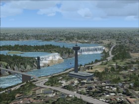
Niagara Falls  is a set of waterfalls on the border between Ontario, Canada and New York, United States. In Flight Simulator the waterfalls are animated together with the Maid of the Mist boat and the Skylon Tower elevator.
Depart from the Canadian side at St. Catharines/Niagara District Airport (CYSN), climb to 3500 ft, and fly east until you reach the Niagara River. Follow the river to the south to the waterfalls. Then turn east and follow the river until you have Niagara Falls Airport (KIAG) on your left hand where you land.
Airspace
The Canadian airspace of the falls is restricted up to 3500 ft. This is visible on both the VFR chart below and in FS. The US airspace of the falls is also restricted up to 3500 ft, and certain restrictions apply for aircrafts flying above 3500 ft. Find these restrictions here and download this scenery file that adds the restricted US airspace to FS.
at skyvector.com
Visit the Victoria Falls in Africa for another waterfall.