Rio de Janeiro
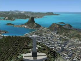
The world famous Rio de Janeiro  is the second largest city of Brazil. The city has a beautiful scenery with its mountains and beaches.
The two major city airports are Galeão - Antônio Carlos Jobim International Airport (SBGL) and Santos Dumont Regional Airport (SBRJ).
In the FSX scenery you'll find e.g. the Christ the Redeemer statue, the Sugarloaf mountain, the Maracanã stadium, and various beaches.
Santos Dumont Airport
Santos Dumont (SBRJ)
 was Rio's first airport and today the second largest. It is located close to the city downtown and it has an excellent view to the mountains and the bay. The airport is rather small but served by many annual passengers.
The main runway is only 4400 feet long, yet used by e.g. Boeing 737s and Airbus A319s. Due to the peninsula with the Sugar Loaf mountain in front of runway 2, there is only circling approaches to that runway, and the area of manoeuvring is limited because of surrounding hillsides. Try them in e.g. the Boeing 737. Remark that the ATC in FSX will only give straight-in visual approaches. You can download charts from this site.
Scheduled flight from Sao Paulo
Try one of the frequent scheduled flights between Sao Paulo and Rio de Janeiro (~ 45 min), where you have a beautiful view of the Atlantic coastline and the mountains. Fly from Congonhas (SBSP) to Santos Dumont (SBRJ) in the Boeing 737.